
From The General’s Hand – Part 2
“All along the untrodden paths of the future, I can see the footprints of an unseen hand.”
Boyle Roche
Published in London in 1801, Letters From His Excellency General Washington, to Arthur Young, ESQ. F.R.S., linked here, contained a reproduction of the map drawn by George Washington. It is not clear who drew the map in this publication, but it contains the same hidden message found in Washington’s original 1793 map. While a large portion of the map is an exact copy, it contains quite a few subtle and not-so-subtle differences compared to Washington’s original map. This map is shown in Figure 2. Image courtesy of The library of Congress, also linked here.
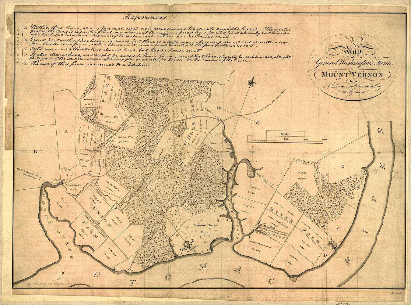
Figure 1 – Mount Vernon map created from drawings transmitted by George Washington
In the same manner that George Washington’s original 1793 map used a spelling error to indicate the presence of a coded message, the 1801 version of this map also uses a spelling error of the same farm name to indicate the presence of a coded message. “DOGUE RUN FARM” is incorrectly spelled as “DOGUE RUR FARM”. The letter “N” is replaced by the letter “R”. This is no mistake, it was intentional.
- The misspelled letter is the 8th letter of the name, and it should be an “N”, not “R”.
- Combine the letter position with the value of “N” = 14, to get 8 + 14 = 814
- The Greek value of “JESUS” is 888
- 888 – 814 = 74 = “JESUS” in the English language.
- This is pointing to the number 74, similar to the clue on the original 1793 map.
The 1801 map replaces the legend in the upper right corner of the 1793 map with an elaborate title artwork. The word “Map” is actually an ambigram that reveals a coded message. An ambigram is an artistic style of writing that conceals a hidden word when the image is inverted. The hidden word can either be the same as the original or different. Two examples of ambigrams are shown below in Figure 2. The first is an ambigram of “Illuminati” that reads the same when inverted. The second ambigram reads “Vida” in normal orientation, and “Morte” when inverted.
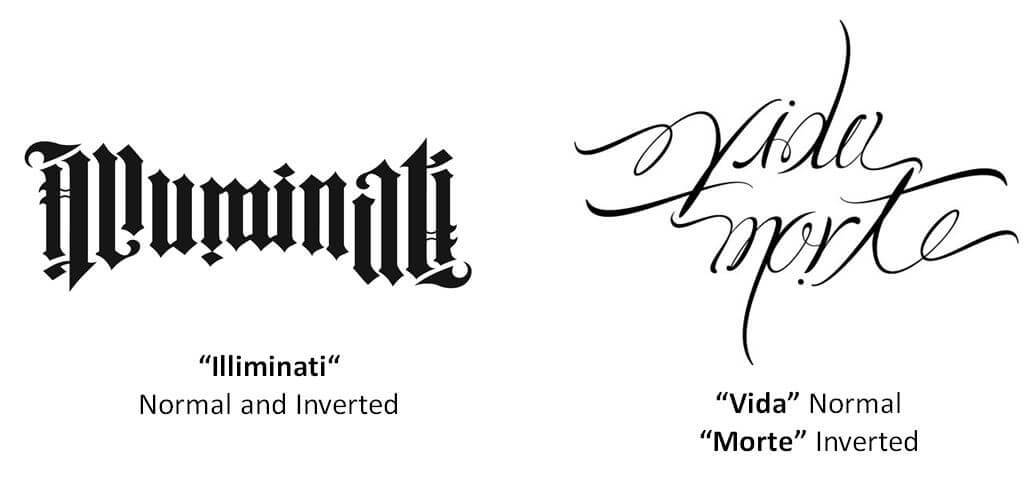
Figure 2 – Ambigram Samples
Figure 3 shows the ambigram hidden in the title of the 1801 map.
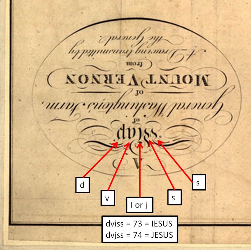
Figure 3 – Ambigram Hidden on 1801 Map
While the inverted image on the map does not actually produce a real word, the letters contain an important gematria clue that relates both to the construction that is hidden on the map and the code in the 1611 King James Bible. There are two possible interpretations of the inverted letters.
- “dviss” = 73 = “IESUS”
- “dvjss” = 74 = “JESUS”
The number 74 repeats the clue hidden in the misspelled “DOGUE RUR FARM”. This is the same clue on the 1793 map that told us to draw lines between fields 7 and 4. The numbers 73 and 74, along with IESUS and JESUS, are directly related to the steps used to decode the King James Bible, indicating that whoever produced this map was aware of the code hidden in the Bible. The letters “I” and “J” in the ambigram also correspond to the associated values for IESUS and JESUS, indicating that this message is intentional.
The total gematria value of the title block is,
“A Map of General Washington’s Farm of Mount Vernon from A Drawing transmitted by the General.” = 887
The total is one less than 888, possibly indicating that something else is hidden in the title. Adding the digits of 887, gives 8 + 8 + 7 = 23 = W.
This could be pointing to the letter “W”. Since the title makes use of the ambigram, perhaps this is a clue to invert the letter “W”. The inverse of “W” is “M”.
Let’s begin the process of decoding the map by looking at the names of the farms. There are 13 words in the names of the five farms.
- “DOGUE RUR FARM MUDDY HOLE FARM RIVER FARM UNION FARM Mansion House Farm” = 704
- If one “Farm” word is not used, then the value is,
- “DOGUE RUR FARM MUDDY HOLE FARM RIVER FARM UNION FARM Mansion House” = 666
- If the estate name, “MOUNT VERNON”. is included, the value is,
- “RIVER FARM UNION FARM DOGUE RUR FARM MUDDY HOLE FARM Mansion House Farm MOUNT VERNON” = 875, which is 13 less than 888.
In the same manner that was used on Washington’s original map, draw line #1 by extending the North-South line of the Compass Rose, see Figure 4. Also draw line #2 by extending the East-West line on the Compass Rose.
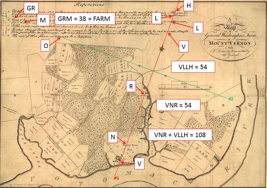
Figure 4 – Extending The Compass Lines on The 1801 Map
The letters intersected by the N-S line have a total value of 108, which will come in to play later. The seven letters are also divided into equal values of 54 above and below the E-W line.
The E-W line intersects the letter “O” in “allowed”. It is worth noting that the original 1793 map by George Washington used the word “given”, which was changed to “allowed” on the 1801 map. The line also intercepts the three letters “GRM” at the top left, which is the same value as “FARM”.
Figure 5 shows a close up view of the words intersected by line 1.
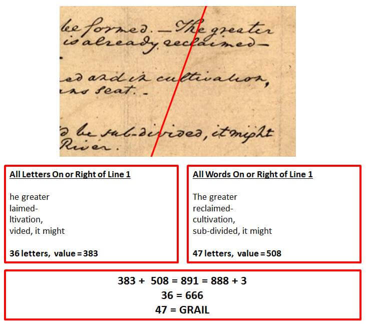
Figure 5 – The words and letters intersected by line #1
- The total value of the complete words to the right of line 1 is 508.
- Added tot he value of the letters intercepted by the line, is 508 + 1-8 = 616.
- A fragment from the oldest surviving copy of the New Testament shows that the number of the beast, referred to in Revelation 13:18, is 616, not 666.
- The total value of the letters on and to the right of line 1 is 383.
- Added together, 383 + 508 = 891 = 888 + 3
- This calls attention to the number 3, possibly to indicate that we should look for three lines that intersect at a single point.
- The number of letters also refers to the number 666 and the GRAIL.
Figure 6 shows a close up view of the words and letters intersected by Line 2.
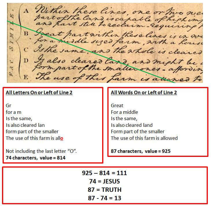
Figure 6 – The words and letters intersected by line #2
- The best clue here is found in the letters to the left of the line. The total value is 814 with 74 characters, not including the last “O”.
- 814 + 74 = 888, the Greek value of JESUS.
- By omitting the “O”, it calls attention to this letter.
To draw line #3, use the omitted letter “O” above as the starting point, and draw a line passing through the word “FARM”, just touching the letters “R” and “M”. as shown in Figure 7. Note that the second letter “O” in “POTOMAC” falls precisely on this line at the bottom of the map.
Following the letter “O” in “ALLOWED”, the letters “WE” could refer to the East-West line. The letter “D = 4” could refer to a 4 degree angle. Line #4 is drawn by connecting the “O” in “POTOMAC” with the center of the compass rose. This line is 4 degrees from the North-South line, exactly the same as was drawn on the 1793 map.
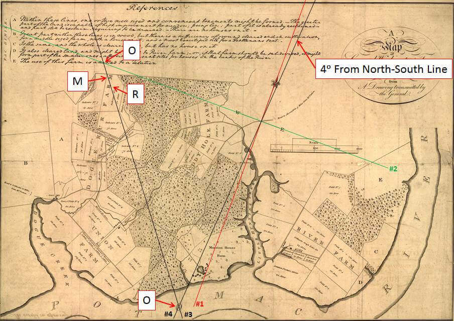
Figure 7 – Construction of Lines 3 and 4 on the 1801 map.
Figure 8 shows the triple “I” intersections for lines 3 and 4. Since “I = 9”, “III” can be interpreted as “999”, which is the inverted mirror image of “666”.
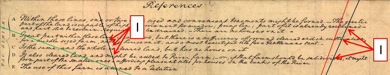
Figure 8 – Detail of Triple “I” Intersections for Lines 3 and 4
Using fields 7 and 4 on the “MUDDY HOLE FARM” and the “RIVER FARM”, lines #5 and #6 are constructed similarly to the lines on the 1793 map, using the top left corner of the letter “N” in each field. The lines are shown in Figure 9.
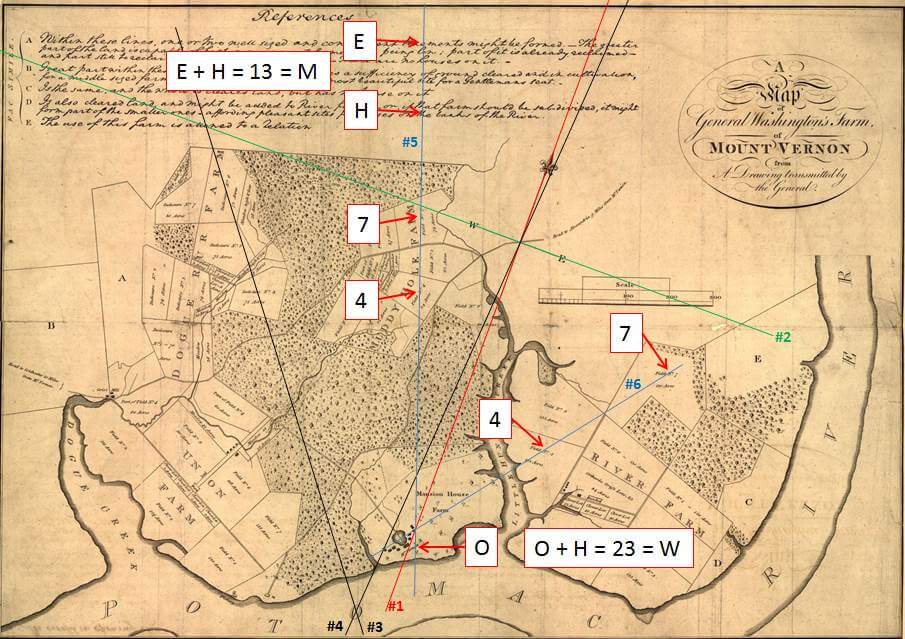
Figure 9 – Construction of Lines 5 and 6
Note in Figure 9, that lines #5 and #6 intersect on top of line #1, forming a triple intersection just north east of the Mansion House, as was also the case on the 1793 map.
The first and last letters intersected by line 5 in the Reference section are “E + H” = 13 = “M”. Line 5 also passes through the “O” in “VERNON” at the bottom of the map. “O + H” = 23 = “W”. Figure 10 shows the construction of line #7, passing through the letters “W” on the Compass Rose and “M” in “MANSION”.
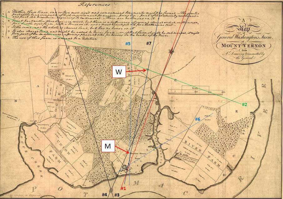
Figure 10 – Construction of Line 7 Passing Through “W” and “M”
The last line required to create the 3-4-5 triangle, line #8, is constructed by drawing a line passing through the intersections of lines 4 & 6 and 1 and 7. Line #8 is shown in Figure 11.
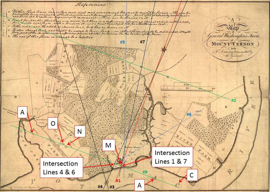
Figure 11 – Construction of Line Number 8
Line #8 is confirmed by the six letters is touches.
AONMAC = 47 = GRAIL
The resulting 3-4-5 triangle is shown in Figure 12, along with the 666 formed by the three lines crossing at each corner of the triangle.
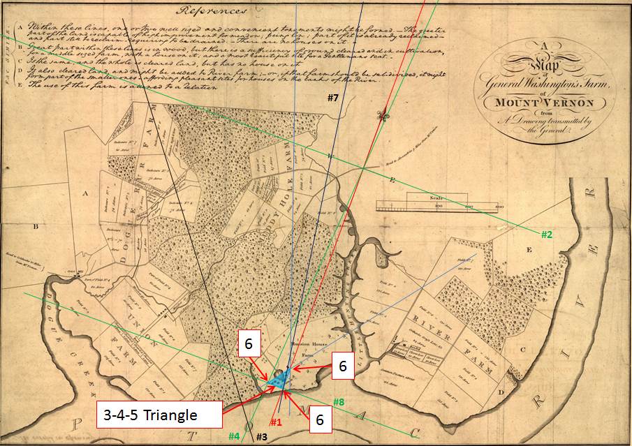
Figure 12 – The 3-4-5 Triangle and The Confirmation Number 666
The next step is to construct the circle of radius 3, centered over the 3-5 corner of the triangle. Line #9 is then drawn by copying the North-South line tangent to the opposite side of the circle. Shown in Figure 13, note that line #9 crosses the letter “W”, along with lines 2 and 7, forming a triple intersection.
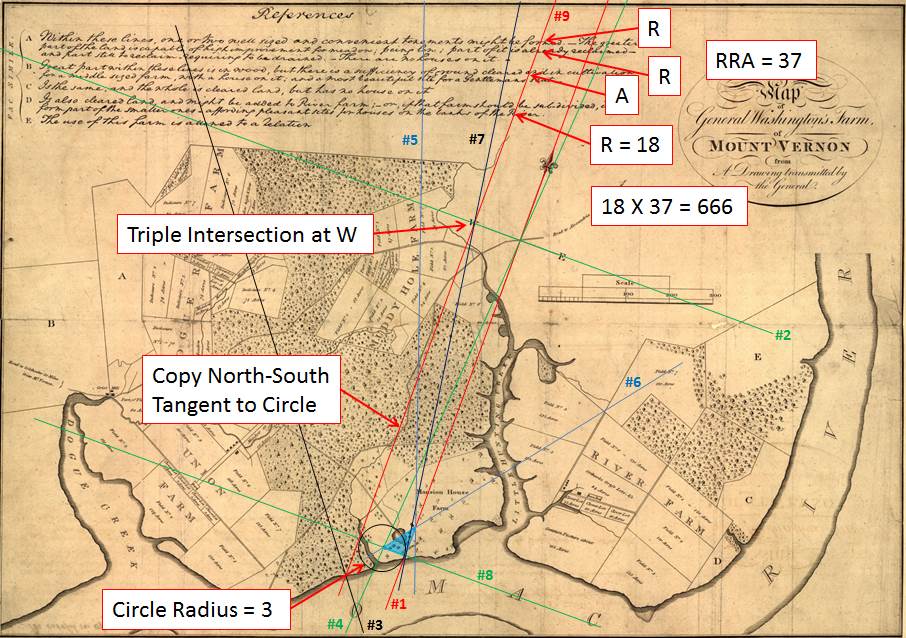
Figure 13 – Construction of The Circle and Line Number 9
The final confirmation of this construction is found in the intersected letters at the top of the map.
- “RRA” = 37, and “R” = 18
- 37 X 18 = 666
- 1837 is also the year that George Washington’s tomb was finally completed with the addition of his marble sarcophagus.
Figure 14 shows the completed Masonic symbol representing The Ark of The Covenant.
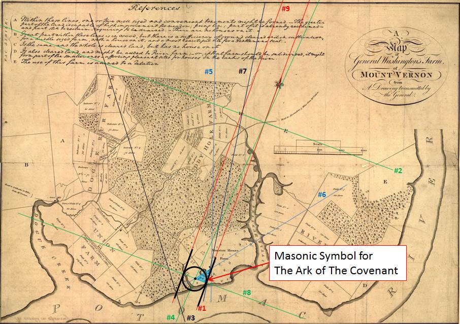
Figure 14 – The Freemason Symbol Representing The Ark of God
This symbol is identical to the one constructed on George Washington’s original map, but George Washington is not believed to have been the creator of this version of the map. The actual author of the map is unknown, but what is undeniable is that whoever created this version, knew the secret that George Washington had encoded on his 1793 map, and they encoded the same secret, but using a different methodology.
The center of the Ark symbol is located precisely over the spot where George Washington’s new family tomb was erected after his death, over the very spot where he indicated that the tomb was to be built.